Hello! I am Latin, from the region of Ajax. Last year I spoke to you about IIwiki and RP. Tonight, I will be speaking about maps, and the role they play in RP and things to keep in mind as you develop your own maps.
To start, I’ll lead with a little about myself and my experiences with cartography. I first began making maps on NS roughly 6 or 7 years ago, many of which were very basic and to put it politely, poor quality. I began working off of tutorials I found in various places, and gradually crafted my own styles and methods. I have served as cartographer of two regions – first in Ixnay from 2015 to 2016, and followed by Ajax since 2017, where I am currently the cartographer. At one point I considered including my own map making tutorial as part, or the whole, of this lecture. However, I felt that it would be a disservice to do so when I can simply link to a few tutorials that I found useful in the early days of my map making below.
Maps Telling a Story
First off, maps are excellent at grounding your story, or setting, and assisting in immersion. Think about it at a basic level, you’re reading a story and the same place names keep appearing. When I see this, I immediately wonder where these locations are relative to the characters and how it fits into the story itself – whether cities, provinces, or landmarks. Similar to my lecture from last year, I consider maps one of the best supplements to RP and aids to grounding a story. Maps can tell you about culture, geography and landscape, and even politics.
Going beyond the aspect of informing the reader in a simple visual where the story is taking place, maps can also tell a story all itself. Simply put, maps tell a story the same way any picture would. In this case, that story is of the nation or entity and the right map can assist in the development of any idea, whether regional or national, or even city.
For example, the map just attached below is of a nation I RP in my region. Now, from simply reading the labels on the map, a few things are apparent. One, this nation is a kingdom, and maintains a sizable domain for the king or queen – simply from the “Royal Domain.” We also see that, in a way, the territories or administrative areas maintain some sort of feudatory relationship at various levels – with Princes, Dukes, and Counts below the monarch, and other lords below them, holding authority over some lesser territory. In a way, the right map can provide key insight into a nation before you ever read a word about it.

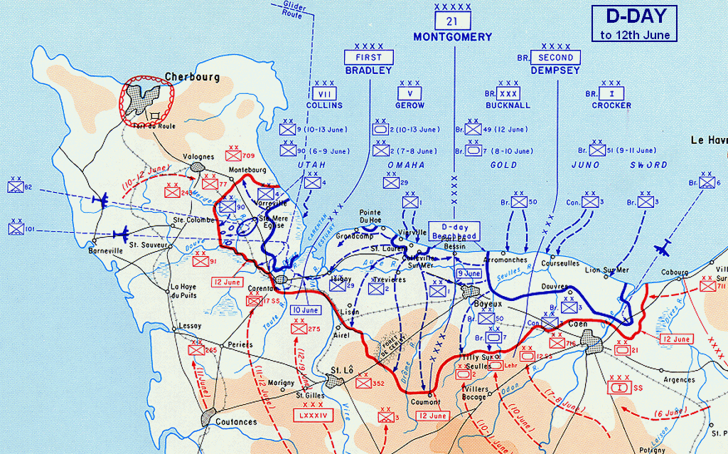
Another key example is war. Yes, for those with an interest in war RP, there is a major opportunity to utilize maps as a valuable tool. There are many ways to demonstrate this, whether basic troop movements or, for those far advanced in the topical specifics than myself, markers to demonstrate the type and number of combatants in any one location and their movements.
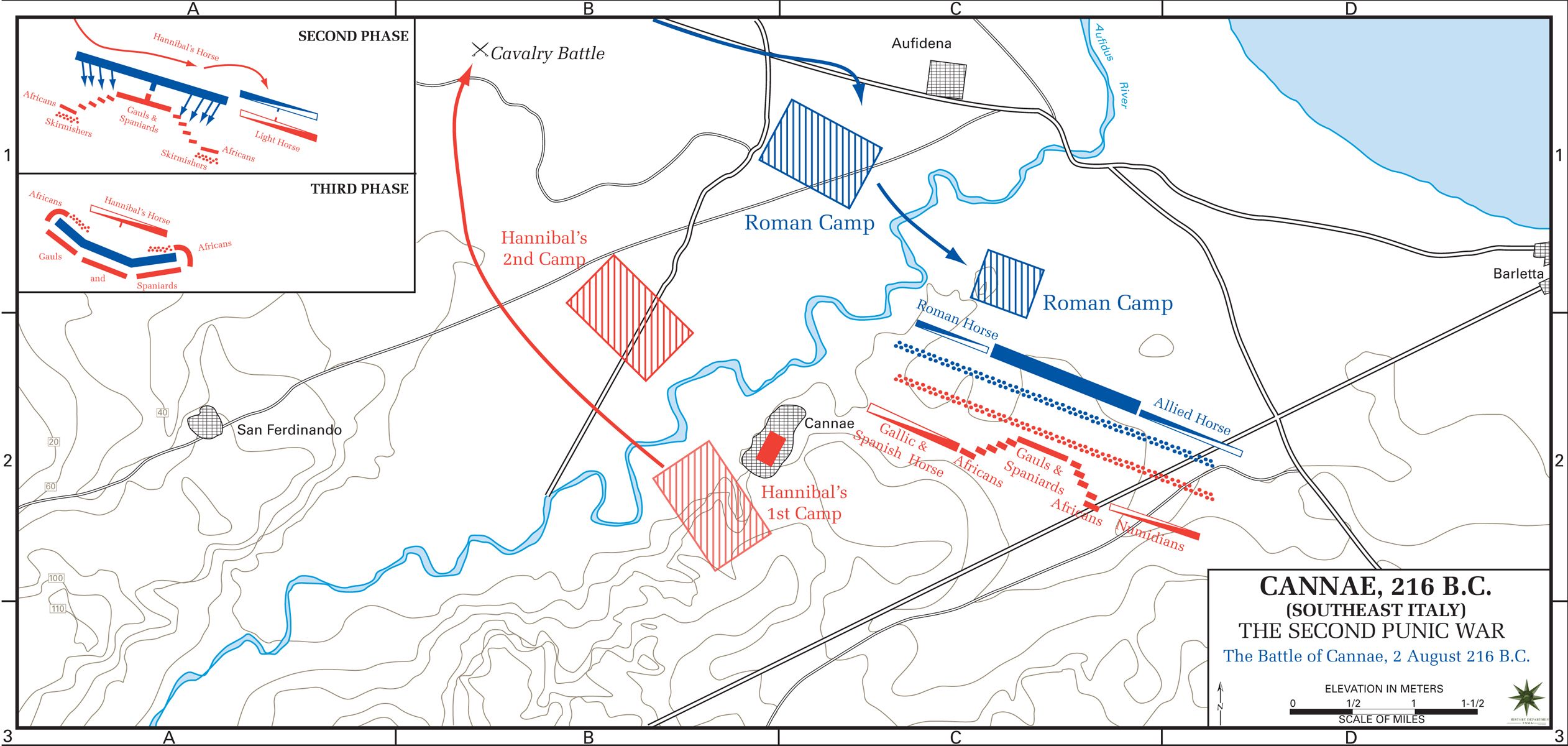
Advanced movements with type and number of personnel.
Things to Keep in Mind
Now, if you’re already in a region that has a map, that is a great start because you already know the canvas you have available. But if you don’t, that’s no problem either. Either way, your first step is the same – you’ll need tools. For me, these are the programs I use for maps, but I have seen people hand draw maps with great success. I primarily use two programs – GIMP and Affinity Designer. GIMP is a free, basic raster graphics editor; think of it as a scaled down, poor man’s version of Photoshop. Did I mention it was free? There’s also paint.net, though I’ve never used it myself. My go to lately, and a far more recent addition to my arsenal is Affinity Designer. Designer is a vector graphics editor, similar to Adobe Illustrator, though at a lower cost. It primarily works in vector but has raster capabilities. A free alternative to Designer or Illustrator is Inkscape. However if you’re running an older computer be sure to save frequently as Inkscape has a history of crashing in my experience.
To briefly touch on the difference between raster and vector. A raster graphic is one in which the image becomes more and more pixelated, or unclear the more you zoom in. A vector graphic is one that does not have that issue and is almost infinitely scalable. All of the maps I have posted here raster graphics; however, many of them were created as vector graphics. This is my preferred format, as I can get into finer detail on the map and it enables me to export the map into .SVG (allowing another user to view it in their vector program the same as I do) or as a raster graphic, such as a .PNG. Many vector graphic programs enable exporting into a variety of other formats, however .SVG and .PNG are the most used by myself. As a note, when exporting a vector to .PNG, you are often able to export to whatever size file your computer can handle – this is where you can dive into great detail on any given map.
Before you begin your map, you need to set a goal, i.e. administrative divisions, road network, major cities, all of the above thrown into one map, or maybe drawing continents. Note, a key thing to remember with any map is to utilize the layer function. While I do the overwhelming majority of my map making in Designer, I almost always start in GIMP. I find it easier to working out a general shape in here due to the simplistic nature of the program and tools at your disposal. This is why I always advise individuals to begin in a program such as GIMP when they an interest in map making. It is much easier to correct mistakes – such as drawing over them with the pencil or clearing them with the eraser tool. This is in clear contrast to a vector program where you are working with nodes and paths and a simple eraser won't correct a minor fix; however, vector programs allow for far greater detail with your projects.
One last bit of advice I would like to impart is to not be afraid to change your map. The three maps below are a good example in the development of a living, changing map. Ask anyone in my region, and they’ll probably say that I loathe altering key aspects of the map, but sometimes changes are key. The first map is the Ajax regional map just before I assumed the role of cartographer. As you can see it was far more compact, and less extravagant. The second is a more recent map, from October. And below that, is a vector map exported into a raster format; however, it remains a work in progress. Some of these changes have been based purely to fix aesthetics, but others have been to make room for areas of the map that see the most new member applications or interest.


Resources
1) Inkscape-Vector map making tutorial
2) GIMP basics and tutorials
3) Wikipedia Map Resources
To start, I’ll lead with a little about myself and my experiences with cartography. I first began making maps on NS roughly 6 or 7 years ago, many of which were very basic and to put it politely, poor quality. I began working off of tutorials I found in various places, and gradually crafted my own styles and methods. I have served as cartographer of two regions – first in Ixnay from 2015 to 2016, and followed by Ajax since 2017, where I am currently the cartographer. At one point I considered including my own map making tutorial as part, or the whole, of this lecture. However, I felt that it would be a disservice to do so when I can simply link to a few tutorials that I found useful in the early days of my map making below.
Maps Telling a Story
First off, maps are excellent at grounding your story, or setting, and assisting in immersion. Think about it at a basic level, you’re reading a story and the same place names keep appearing. When I see this, I immediately wonder where these locations are relative to the characters and how it fits into the story itself – whether cities, provinces, or landmarks. Similar to my lecture from last year, I consider maps one of the best supplements to RP and aids to grounding a story. Maps can tell you about culture, geography and landscape, and even politics.
Going beyond the aspect of informing the reader in a simple visual where the story is taking place, maps can also tell a story all itself. Simply put, maps tell a story the same way any picture would. In this case, that story is of the nation or entity and the right map can assist in the development of any idea, whether regional or national, or even city.
For example, the map just attached below is of a nation I RP in my region. Now, from simply reading the labels on the map, a few things are apparent. One, this nation is a kingdom, and maintains a sizable domain for the king or queen – simply from the “Royal Domain.” We also see that, in a way, the territories or administrative areas maintain some sort of feudatory relationship at various levels – with Princes, Dukes, and Counts below the monarch, and other lords below them, holding authority over some lesser territory. In a way, the right map can provide key insight into a nation before you ever read a word about it.
Another key example is war. Yes, for those with an interest in war RP, there is a major opportunity to utilize maps as a valuable tool. There are many ways to demonstrate this, whether basic troop movements or, for those far advanced in the topical specifics than myself, markers to demonstrate the type and number of combatants in any one location and their movements.
Advanced movements with type and number of personnel.
Things to Keep in Mind
Now, if you’re already in a region that has a map, that is a great start because you already know the canvas you have available. But if you don’t, that’s no problem either. Either way, your first step is the same – you’ll need tools. For me, these are the programs I use for maps, but I have seen people hand draw maps with great success. I primarily use two programs – GIMP and Affinity Designer. GIMP is a free, basic raster graphics editor; think of it as a scaled down, poor man’s version of Photoshop. Did I mention it was free? There’s also paint.net, though I’ve never used it myself. My go to lately, and a far more recent addition to my arsenal is Affinity Designer. Designer is a vector graphics editor, similar to Adobe Illustrator, though at a lower cost. It primarily works in vector but has raster capabilities. A free alternative to Designer or Illustrator is Inkscape. However if you’re running an older computer be sure to save frequently as Inkscape has a history of crashing in my experience.
To briefly touch on the difference between raster and vector. A raster graphic is one in which the image becomes more and more pixelated, or unclear the more you zoom in. A vector graphic is one that does not have that issue and is almost infinitely scalable. All of the maps I have posted here raster graphics; however, many of them were created as vector graphics. This is my preferred format, as I can get into finer detail on the map and it enables me to export the map into .SVG (allowing another user to view it in their vector program the same as I do) or as a raster graphic, such as a .PNG. Many vector graphic programs enable exporting into a variety of other formats, however .SVG and .PNG are the most used by myself. As a note, when exporting a vector to .PNG, you are often able to export to whatever size file your computer can handle – this is where you can dive into great detail on any given map.
Before you begin your map, you need to set a goal, i.e. administrative divisions, road network, major cities, all of the above thrown into one map, or maybe drawing continents. Note, a key thing to remember with any map is to utilize the layer function. While I do the overwhelming majority of my map making in Designer, I almost always start in GIMP. I find it easier to working out a general shape in here due to the simplistic nature of the program and tools at your disposal. This is why I always advise individuals to begin in a program such as GIMP when they an interest in map making. It is much easier to correct mistakes – such as drawing over them with the pencil or clearing them with the eraser tool. This is in clear contrast to a vector program where you are working with nodes and paths and a simple eraser won't correct a minor fix; however, vector programs allow for far greater detail with your projects.
One last bit of advice I would like to impart is to not be afraid to change your map. The three maps below are a good example in the development of a living, changing map. Ask anyone in my region, and they’ll probably say that I loathe altering key aspects of the map, but sometimes changes are key. The first map is the Ajax regional map just before I assumed the role of cartographer. As you can see it was far more compact, and less extravagant. The second is a more recent map, from October. And below that, is a vector map exported into a raster format; however, it remains a work in progress. Some of these changes have been based purely to fix aesthetics, but others have been to make room for areas of the map that see the most new member applications or interest.
Resources
1) Inkscape-Vector map making tutorial
2) GIMP basics and tutorials
3) Wikipedia Map Resources
Last edited: